Behind the Scenes
A Museum Map in Xi'an Made Me Lay Tang Dynasty Chang'an Over the Modern City
By the POMODIARY Team · · 6 min read
On a trip to Xi'an, I came across a fascinating map in the Shaanxi History Museum.
It was really two maps laid on top of each other. The upper layer showed the whole city of Chang'an at the height of the Tang Dynasty (618–907), the capital that Xi'an used to be: more than a hundred walled residential wards, the East and West Markets, the Daming Palace and the Xingqing Palace, all drawn out clearly. The lower layer showed the streets of Xi'an today. With the two layers stacked, you could tell at a glance which Tang ward the spot you were standing on used to belong to.
That moment hit me. Chinese schoolchildren memorize Tang poems about Chang'an, lines like Du Mu's "looking back at Chang'an, the hills are heaped like brocade" and Wang Wei's "the nine heavenly gates open on palace halls." Yet for most people, "Chang'an" stays an abstract word. Only when a map presses it down onto streets you know do you suddenly realize: the city that Li Bai and Du Fu walked through is right under your feet, and it has not moved in thirteen hundred years.
I thought: how good it would be to turn this into a web page that anyone visiting Xi'an could open on their phone.
So I actually built it.
This post was first written in Chinese for the developer's WeChat Official Account (a blog-style publishing channel inside the WeChat messaging app) and adapted for English readers.
What it looks like
The finished product is a map that "breathes."
There is a slider on the screen, and its handle is a Kaiyuan Tongbao, the bronze coin of the Tang Dynasty. Drag it and the view slowly crossfades between "Xi'an today" and "Chang'an of the Great Tang." The modern streets gradually fade away, and the ward walls outlined in cinnabar red, the palace city painted in gold, and the Qujiang Pond drawn in azurite blue emerge bit by bit.
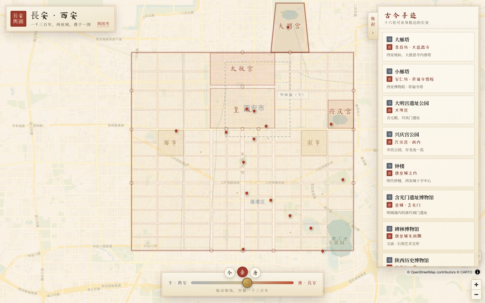
I deliberately styled it like a color painting on silk: cinnabar, gold and azurite, with ward names written vertically in a handwritten script, like an old map unrolled on a table.
You can:
- Drag the coin slider to travel freely between today and the Tang.
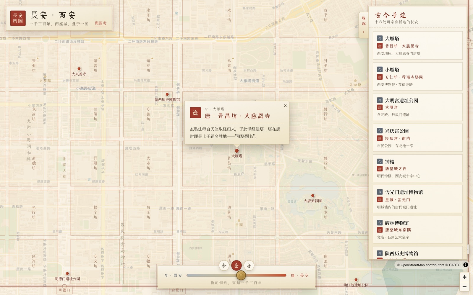
- Tap anywhere on the map, and a popup tells you which ward the ground under your feet belonged to in the Tang. Famous wards come with a story. Tap Pingkang Ward and it tells you this was Chang'an's "Beili," the pleasure quarter that newly minted imperial examination graduates loved to visit. Tap Qinren Ward and you learn it was once the residence of the general Guo Ziyi, where "flowers were planted in front of the hall and singing was taught behind it."
- Follow the sixteen red pins to the pieces of Chang'an you can still visit in person today: the Big Wild Goose Pagoda, the Small Wild Goose Pagoda, Qinglong Temple, the Daming Palace, Hanguang Gate, the Great Tang West Market and more. Each one has a "today ↔ Tang" comparison card.
The moment that stunned me most
While making the map, one detail gave me goosebumps.
I drew a dashed line on the map: the Ming-dynasty city wall of modern Xi'an, the ring that tourists climb and stroll along today.
Then I switched to "Tang" mode.
Guess what? The old city wall of Xi'an, which we think of as huge, big enough that people rent bicycles to ride around the top of it, takes up only a small patch in the northeast corner of Tang Chang'an.
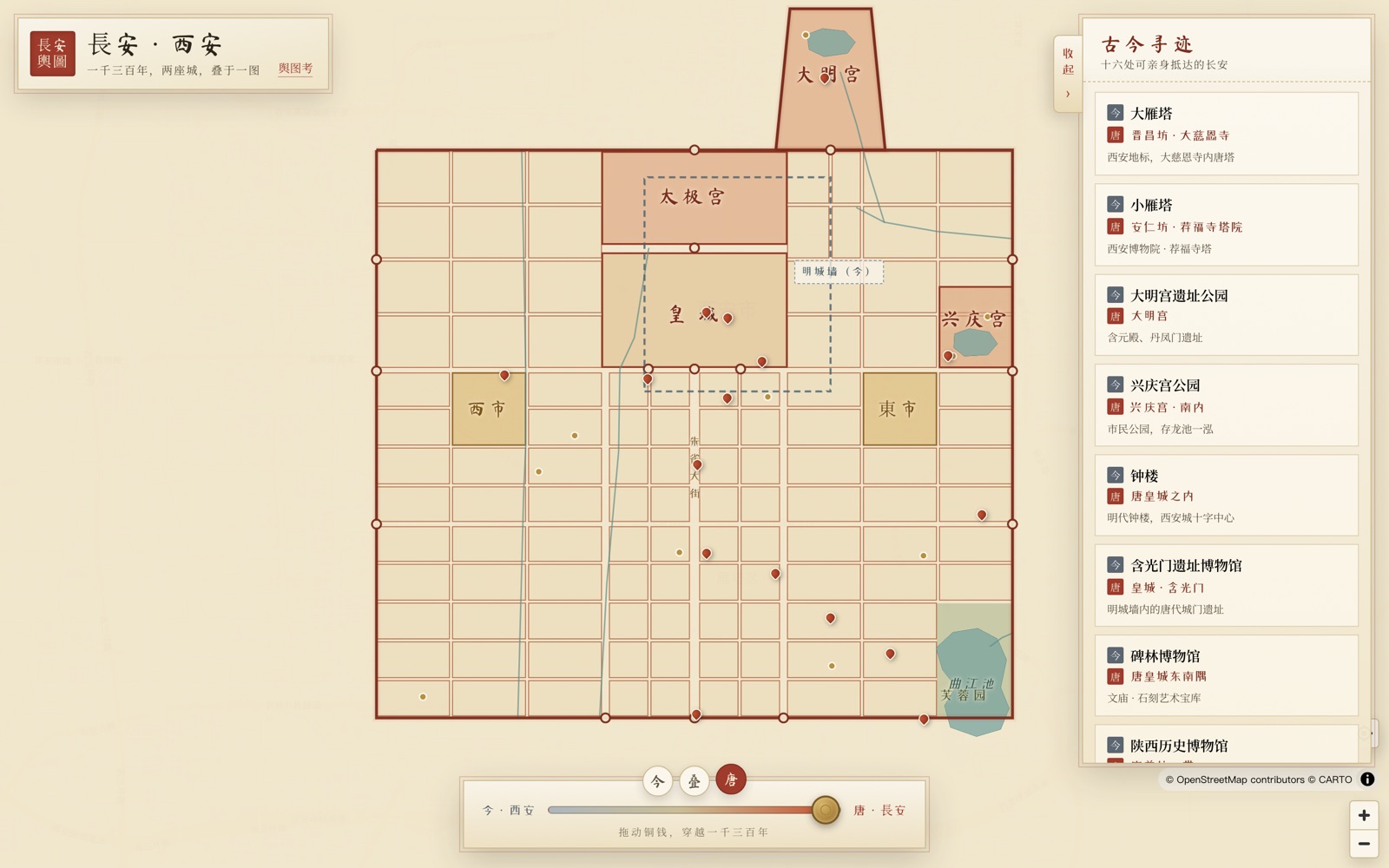
Tang Chang'an measured about 9.7 kilometers from east to west and about 8.6 kilometers from north to south. Its area was several times that of the "old city" enclosed by today's Ming wall. The "old city" we walk around is really just the Tang imperial city and a little of the area north of it. The real Chang'an spread out endlessly to the south, the east and the west.
Only then did I really understand what the poets meant by "the nine heavenly gates," or by "the robes and caps of ten thousand nations bow before the emperor's crown."
This map was carefully researched
The thing I most want to make clear is this: I did not sketch Tang Chang'an in by hand. It was aligned, inch by inch, to real latitude and longitude.
- The layout of the ward names was checked column by column against volumes 7 to 10 of the Chang'an Zhi (Records of Chang'an), written by Song Minqiu in the Song Dynasty. The overall scheme follows the line in the Tang Liudian (Six Codes of the Tang): "South of the imperial city, ten wards from east to west and nine from north to south; on each side of the imperial city, twelve wards; the two markets occupy the space of four wards; one hundred and ten wards in all."
- The anchor points are three Tang remains that are still on their original sites: the Mingde Gate ruins (which fix the central axis of Zhuque Avenue), the Hanguang Gate ruins (which fix the south wall of the imperial city), and the Danfeng Gate ruins (which fix the position of the north wall).
What reassured me most was the "self-check" after the alignment was done. I did not try to force anything to line up, and yet:
- The Big Wild Goose Pagoda lands right in Jinchang Ward (home of the Tang Da Ci'en Temple, where the monk Xuanzang translated scriptures and built the pagoda).
- The Small Wild Goose Pagoda lands right in the northwest corner of Anren Ward (matching exactly the position of the Jianfu Temple pagoda courtyard recorded in the histories).
- Daxingshan Temple sits right in the middle of Jingshan Ward (an imperial temple of the Sui and Tang, whose site has not moved in fourteen hundred years, from the Sui Dynasty to today).
- Qinglong Temple is right in Xinchang Ward (where the Japanese monk Kūkai studied esoteric Buddhism before returning home to found the Shingon school).
- The Great Tang West Market Museum sits right on top of the original site of the Tang West Market.
A thousand years of city fabric, confirming itself on one map.
Of course, it is still a schematic reconstruction: ward boundaries and streets are approximate, and the waterways are drawn impressionistically, so it cannot be used as archaeological evidence. The site has a dedicated page, "Notes on the Map," that honestly lays out all the sources and every caveat.
For you, if you are coming to Xi'an
I built this with no commercial purpose at all. I simply felt this:
If you are standing at the crossroads by the Bell Tower, you can know that the ground under your feet was the imperial city where officials went to court in the Tang. If you are queuing beneath the Big Wild Goose Pagoda, you can know that thirteen hundred years ago this was Jinchang Ward, where Xuanzang translated scriptures. If you are wandering the Muslim Quarter eating paomo (crumbled flatbread in mutton soup), you can know that this bustle and the aromas of the foreign merchants' taverns in the Tang West Market share one lineage.
Then your trip to Xi'an is more than ticking off sights. You will have truly come face to face with the city, and with that golden age.
Chang'an has always been here. It just changed its name to Xi'an.
I made the map into a website, changan.pomodiary.com. It works on phones and computers, opens instantly, and needs no app. Next time you go to Xi'an, take it along and, as you walk, follow the streets back to the Tang.
Keep reading
- I Turned Watching Ants Haul Insects as a Kid into 20 New Game Levels
Crumb Colony chapter six adds 20 insect levels where the key box hides deep in the tray. How I used bots to build levels you cannot solve by logic alone.
- A 100K-Download App Sat Quiet for Two Years. After a 13-Day Revamp, It Started Earning Again
Pomodoro Diary had 100K+ downloads but no real update in a year or two. We merged 53 PRs in 13 days to rebuild it, and paid orders started coming back in.
- I Made a Little Game About Ants Carrying Pixel Art Home, One Bite at a Time
Crumb Colony is a free browser puzzle game: release colored ants and watch them carry a pixel-art dish to their nest, bite by bite, across 20 solvable levels.